Rosewood History
Mason’s Bridge
Richard Mason selected his pastoral land on the 6th August 1869, in the infant years of the settlement of Rosewood. The family was among the earliest settlers. His previous experience working as a timber-getter on the Fraser Coast gave him an advantage when it came time to clear his own land. He built a small cottage on his selection which was located on the north eastern corner off the present day roundabout on John Street.
The virgin bushland that he and other settlers encountered was so dense that to get to and from their farms to the centre of the settlement it was necessary to walk along the railway line and veer off along Cowell’s Road at various junctures. To compound matters, a natural water course originating from the hills above Richard Mason’s land, ran through his farm and down through the town making the main street impassable, even to him.
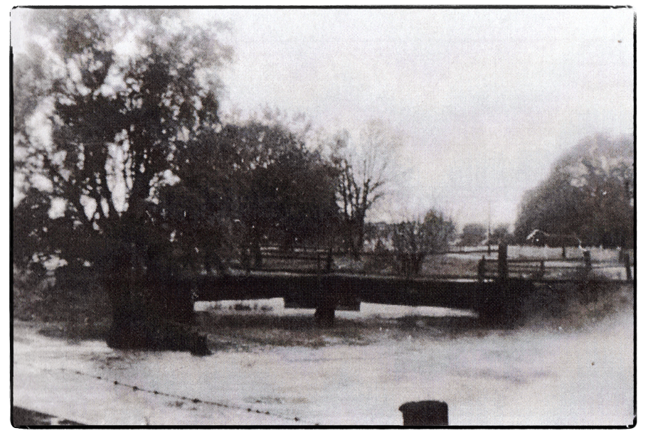
The problem was solved when a timber bridge was constructed near Richard’s farm and it became known as Mason’s Bridge. It originally spanned the water course and was about half-a-mile (.8 km) from the railway station.
Mason’s Bridge was finished in late March 1876. A correspondent for the Queensland Times wrote this: Here we noticed a very substantial and neatly finished bridge which was receiving its finishing touches and which had been erected for the convenience of settlers to the east of the main road, who previously had to go a long way round to reach the railway station.
Rosewood’s first butchering business was opened by Henry McGeary. In those early days there was no bridge over the Bremer River and Henry used to slaughter his animals at Mt Walker then cart the meat to Rosewood via the Seven Mile. His customers used to meet his cart near Mason’s Bridge to have their orders cut for them on Henry’s butcher block.
This main throughfare carried a lot of traffic which made the bridge an opportune place to pin up notices to inform the public of meetings etc and it was also a place at which some open air meetings were held.
A portion of Richard Mason’s land was resumed by the Government and in 1884 a dam was constructed on part of his original selection. It became known locally as Mason’s Dam.
Three weeks of repairs to the bridge were completed in July 1891 by contractors Donaldson and Moore at a cost of £6. In 1909 ganger Henry Berlin gravelled the bridge. In 1924 it was reportedly in a dangerous condition, so minor repairs were done to the bridge, work was done on the drain and noxious weeds were removed on the surrounding land. Three chains of metalling and boxing work was completed in 1928 and and there were more repairs in 1934. More maintenance work would certainly have been carried out in the ensuing years between then and 1966 when the bridge was damaged by flooding, and the concrete pipes that are in place today at Mason’s Gully were installed.
Local residents tell of how in the 1950’s and 60’s there was a substantial water hole under the old wooden bridge. In periods of heavy rain it flooded and water overflowed the cement drain which runs through the town.
Mason’s Bridge was a great place to meet friends on weekends. Young people swam and fished in the waterhole, sometimes catching little perch or eels, and sometimes turtles. Some fished for yabbies with a piece of string or cotton and some talked of jumping off the high bank into the water.
On the north side of the bridge there was a large flat, well grassed area that naturally lent itself for use as a cricket field. A batsman could belt a six without fear of hitting neighbouring properties.
On the south side of the bridge the vacant land became known as “Itchy Park”. The reason given for this name has various explanations, from the presence of bird lice (due to the area being popular for nesting Magpies) to referring to a lovers’ tryst (as this was also a popular meeting place).
Here are a couple of articles which may be of interest.
ROSEWOOD REST SITE SUGGESTED – ROSEWOOD, March 23, 1953 (Q.T.)
The Rosewood and District Progress Association at a well attended meeting in the School of Arts decided to suggest to the Moreton Shire Council a site in Rosewood for a roadside rest area. Mr. P. E. Freeman presided. Following the association’s request to the council for the establishment of rest areas close to the town, the council sought further information on the request. The Secretary. (Mr. G. Keegan) was instructed to advise the council that the association suggested a rest area in the park in John Street between Mason’s bridge and the concrete drain, and the provision of a building, tank, and sanitary conveniences. It was agreed also to ask the council to have dead trees removed from the area.
FIVE UNHURT IN CAR’S I5 FT. FALL – ROSEWOOD Thursday Feb. 25, 1954 (Q.T.)
A Marburg couple and their three children escaped uninjured when the tourer car in which they were traveling crashed over the side of Mason’s Bridge at North Rosewood tonight and fell shout 15ft, to the gully below. The car, owned by Walter John Anderson, Marburg, was being driven by his wife, Ethel Mavis Anderson, along John Street towards the shopping centre about 6.10 p.m. The driver made a left hand turn on to Mason’s bridge and the car got out of control, ran over the kerbing of the bridge, and fell into the gully. The vehicle, an old model with a fabric hood, came to rest facing the way it had come. The crash was heard at the Rosewood Ambulance Centre and a car was sent to the bridge. Anderson, his wife, and their three children were examined for injury, and it was found they had escaped except for shock. The car later was brought back on to the road.

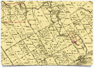
A map showing the location of Cowell’s farms, Richard Mason’s farm, Mason’s Bridge and Mason’s Dam. (Further information on which road was known as Cowell’s Road is still being sought.)
© Jane Schy, 2024
